


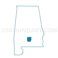
BOILING, Butler County, Alabama
About
Outline

Summary
| Unique Area Identifier | 521281 |
| Name | BOILING |
| County | Butler County |
| State | Alabama |
| Area (square miles) | 13.23 |
| Land Area (square miles) | 13.23 |
| Water Area (square miles) | 0.00 |
| % of Land Area | 99.97 |
| % of Water Area | 0.03 |
| Latitude of the Internal Point | 31.74191010 |
| Longtitude of the Internal Point | -86.69539370 |
Maps


Graphs
Select a template below for downloading or customizing gragh for BOILING, Butler County, Alabama


Neighbors
Neighoring Voting District (by Name) Neighboring Voting District on the Map
- CHAPMAN POST OFFICE, Butler County, AL
- GREENVILLE NATIONAL GUARD ARMORY, Butler County, AL
- MCLAIN'S, Butler County, AL
- ROCKY CREEK, Butler County, AL